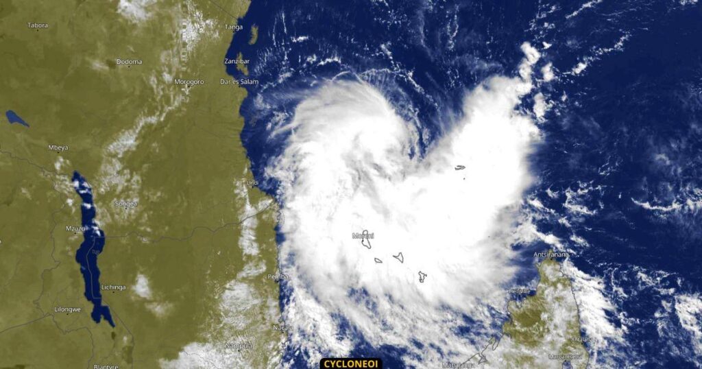
- Kenya and Tanzania, already reeling from nature’s fury, now confront the looming threat of Cyclone Hidaya.
- Cyclone Hidaya’s trajectory places the eastern coast of Tanzania squarely in its crosshairs as neighbouring Kenya braces for floods.
- The relentless deluge gripping East Africa originates in the El Nino weather pattern.
Millions of people in Tanzania and Kenya are on edge as Cyclone Hidaya, a formidable tempest, barrels toward the region, exacerbating the havoc wrought by ongoing heavy downpours and catastrophic floods that have claimed hundreds of lives across East Africa.
Kenya and Tanzania, already reeling from nature’s fury, now confront the looming threat of a cyclone poised to unleash further devastation, with forecasts predicting a grim landfall later on Friday, May 3rd.
Cyclone Hidaya’s trajectory currently places the eastern coast of Tanzania squarely in its crosshairs, with fears mounting over its potential impact on neighbouring Kenya. As meteorological projections paint a dire picture, anticipation grips coastal populations, bracing for the onslaught of heavy rains, surging waves, and ferocious winds across flood-hit Kenya and Tanzania.
Lives lost as floods sweep across East Africa
Reeling from the toll of relentless downpours, Kenya is a testament to nature’s unforgiving wrath. The latest communique from the country’s Ministry of Interior and National Administration lay bare the grim toll: at least 120 lives have been lost since March, with scores injured, missing, and hundreds of thousands displaced in the wake of rampaging floods.
With Cyclone Hidaya’s massive spectre looming, Kenya’s President, Dr William Ruto, has sounded the alarm, issuing a mandatory evacuation for hundreds of households in vulnerable areas surrounding 178 dams and water reservoirs across 33 counties. Additionally, the citizens have been urged to maintain vigilant preparedness amidst the looming threat, as authorities ramp up efforts to mitigate potential catastrophe and loss of lives.
The relentless deluge gripping East Africa originates in the El Nino weather pattern, a climatic phenomenon notorious for its capricious nature. While some parts of the world grapple with parched landscapes, East Africa is inundated by heavy rainfall, exacerbating the humanitarian crisis unfolding across the region.
Tanzania is bearing nature’s fury, with recent weeks witnessing a grim tally of lives lost to flooding and landslides. Cyclone Hidaya looms ominously on the horizon, and further upheaval casts a pall over the nation, prompting heightened vigilance and preparatory measures to confront the impending storm.
Far-reaching implications of Cyclone Hidaya
Amidst the mounting crisis, the Tanzania Red Cross Society issues a sobering warning, highlighting the far-reaching implications of Cyclone Hidaya’s arrival. The anticipated onslaught, characterized by torrential rains and gale-force winds, threatens to compound the woes already afflicting communities along the Indian Ocean coastline, amplifying the scale of the humanitarian emergency gripping the nation.
Beyond the borders of Kenya and Tanzania, neighbouring Burundi is grappling with its share of nature’s fury, as heavy rains heavily affect lives and livelihoods. The United Nations sobering statistics paint a dark reality: at least 29 lives lost, scores injured, and tens of thousands displaced since the onset of the rainy season last year, further amplifying East Africa’s vulnerability to climatic woes.
As Cyclone Hidaya hurtles toward the East African coast, communities brace themselves for the imminent deluge, grappling with the sobering reality of nature’s unpredictable fury.
Read also: COP28 failures: Climate change undermines Africa’s food security
What you need to know about Cyclone Hidaya
- The storm is currently at a severe warning level, with maximum significant wave height reaching 7.9 meters (26 feet), and is forecast to make landfall tomorrow.
- It is predicted to intensify to a peak of 165 km/h (90 knots) in around 24 hours as the environment remains conducive with high moisture content.
- Anticipated periods of heavy rain and strong winds in Mtwara, Lindi, and Pwani (including the Mafia Islands), according to @tma_services
