Mapping “Adaptech”: introducing a multi-dimensional map of over 70 digital technologies for climate adaptation
Climate change adaptation has been a significantly underfunded area in low-income countries. At the United Nations Climate Summit in Copenhagen 2009, high-income countries made a pledge to provide US$100 billion per year to low-income countries to help them adapt to climate change and mitigate further rises in temperature. To date this amount of investment has not yet been reached in a single year. Among the investments that have been made, less than 30% have been applied to climate change adaptation with the majority of investments applied to climate change mitigation.
Climate change adaptation helps countries and their citizens to prevent catastrophic effects on lives and property from droughts, floods, cyclones, storms; sea-level rise, increased salination, as well as temperature fluctuations. Investments in climate change adaptation are not some theoretical forward-thinking issue, but can directly save lives from being lost and property from being decimated in severe storms, floods, and droughts today.
Digital technologies for climate adaptation or “Adaptech” solutions have the ability to maximize the use of limited funding in order to save lives and protect property. Unlike advanced innovations in energy storage or new forms of renewable energy that require technical breakthroughs to occur before they are applicable in low income countries, digital technologies for climate adaptation are can be designed, built, tested, and implemented today. Recent advances in “no-code” digital technologies further reduce the time and cost of digital development by as much as 80% and allow for non-technical developers to create viable digital products in days as opposed to months.
Adaptech can make limited climate funding go further, increase transparency and traceability, improve measurement of solutions, and help people in low income countries more effectively than ever before.
In collaboration with Devfin, Stratera Capital created this multidimensional map of over 70 different “Adaptech” solutions.
This Adaptech map can be used in several ways by global development partners, impact & venture investors, researchers and especially entrepreneurs.
For this study we selected 4 countries (Kenya, Mozambique, Bangladesh, and Colombia) and reviewed their National Adaptation Plans and Nationally Determined Contribution reports to identify clusters of the most severe risks to lives and property which included:
- Drought and temperature rise (D),
- Flood, cyclones, & storms (F),
- Sea level and salination (S)
The following sectors were identified as being of high priority and need of climate adaptation from the climate risks listed above:
- Food security – covering agriculture, livestock, fisheries, drinking water sectors
- Natural systems – covering forests, oceans, biodiversity sectors
- Human settlements – covering infrastructure, energy, housing, industry, waste
- Human heath – covering casualties, disease management, air quality
To make sense of the dozens of different digital technologies relevant to climate adaptation we categorized the functions and actions that these digital technologies contribute to developmental actions.

Digital technology functional areas
Digital technologies were categorized into functional areas including:
- Collect – technologies that track, measure, monitor, store information or resources. Examples include sensors, IoT, remote sensing, satellite imagery, drones, blockchain, and databases.
- Assess – technologies that analyse, predict, evaluate, visualise, map, model, test theories, simulate, inform, and/or support decision making. Examples include algorithms, machine learning, big data, statistical analysis, data science, VR/AR, digital twins for scenario planning, and geographic information system (GIS).
- Connect – technologies that bring parties together, aggregate, match demand with supply, coordinate, pool resources, transact, and/or support trade of information or resources. Examples include matching algorithms, machine learning, websites, marketplaces, and social media.
- Distribute – technologies that inform, communicate, share information or resources, educate, teach, learn, build capacity, and/or sell information or resources. Examples include Mobile phones, social media, SMS, broadcast networks, mobile money, cryptocurrency, lend, and digital insurance.
- Manage – technologies that plan, regulate, set policies, limit, govern, optimize, make decisions, enforce rules, taking action, validate, authenticate, and/or nudge people, information or resources. Examples include smart contracts, decision support tools, templates, sensor management, workflow systems, and setting of system defaults.
Applying these technology functions of collect, assess, connect, distribute, and manage against impact categories of food security, natural systems, human settlements, and human heath allowed us to map the different technologies in context of their priority risk areas of drought and temperature rise; flood, cyclones, & storms; and sea level rise and salination.
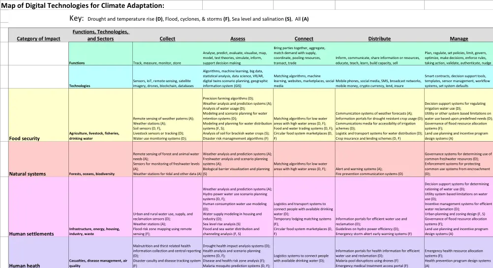
Map of Adaptech – Digital Technologies for Climate Adaptation
In this map of digital technologies for climate adaptation we see the functions and technologies listed in the horizontal axis, the categories and sectors listed in the vertical axis, and the specific uses of the technologies listed in the inner boxes of the table. Each of the technologies listed is denoted with a letter for the area of impact relevant to the technology including (D) for drought and temperature rise; (F) Flood, cyclones, & storms; (S) Sea level and salination; and (A) for technologies whose impact can cover all 3 risk areas.
To illustrate we can see the Collect column and Food Security row a digital technology for adaption included as “Remote sensing of weather patterns (A)”. This lists the use of satellite imaging systems called remote sensing for evaluating weather in a particular country or region. These satellites collect information on weather in a particular region relevant to food systems specifically agriculture, livestock, and/or fisheries and can be analyzed by humans or other systems. Climate change can require adaptations relevant to the risks of drought and temperature rise; flood, cyclones, & storms; and sea level and salination. Since all 3 priority risks are listed, the technology of “Remote sensing of weather patterns” is listed with an (A) as relevant for all of the 3 priority risks.
This map of digital technologies for climate adaptation can be used by climate adaptation practitioners in the following ways with the following examples:
- To track and monitor the development and application of different technologies and use in development and humanitarian contexts. For example, weather station data used in government rescue missions in Bangladesh could be used on planning in Mozambique. Tracking and monitoring could be useful to encourage distribution/diffusion of useful climate tech tools, as well as ease coordination and cooperation among and with partner organizations.
- To identify opportunities to use technology solutions to increase impact. For example, a project in agriculture capacity building in Mozambique can explore weather station applications to improve outcomes for farmers’ livelihoods. This can support climate adaptation practitioners in increasing internal collaboration among different contributions and programs in a country or region.
- To identify complementary technologies for use in existing or new portfolios. For example, an agriculture project using weather station data in Mozambique could apply AI or other algorithms to help in planning purposes and/or a mobile phone application to share weather alerts.
For entrepreneurs, the entire sector of Adaptech is largely untouched, has strong potential support for significant funding from the developmental community, can scale similar to other digital technologies, and has market opportunities serving the majority of world’s inhabitants.
One example is the announcements by organizations like the UN seeking to enable every person on Earth in range of an early-warning system.
Whereas Adaptech development may be relatively easy compared to other forms of technology implementation, integration among stakeholders is likely more challenging.
A selection of some of the variety of stakeholders are included in the table below:
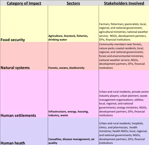
To illustrate the players involved, we can consider an example of a digital mobile phone-based weather information solution used by farmers in a low income country would require interaction with and approval by the farmers themselves; the relevant cooperatives the farmers belong to; the domestic telecom operators who would be sending the messages or providing the data to use the system; electrical service providers to ensure that the farmers have affordable access to keep their phones charged; the domestic weather service to provide the information as inputs to the system; the agricultural ministries who govern what can and can’t be done with and for farmers; the local governments where the farmers are working who serve as community leaders on new ideas and implementations; local NGOs and businesses to support awareness campaigns for the digital solution and training on how to use it; development partners who are also likely working with the same farmer groups in the country on adjacent or complimentary interventions; investors and funders to pay for the solutions or the infrastructure around the solution; and businesses or service providers to provide tools, inputs, offtakes, or other resources for actions to be taken from decisions made by using the digital tool. To not include one or more of these stakeholder groups in the conceptualization, design, piloting, or rollout can impact the likelihood of success.
In mapping Adaptech and the related opportunities, we hope to guide more effective use of limited investment funding while helping to accelerate the efforts to save lives and property from present and future risks using tools that are already available.
By David L. Ross, Managing Director, Stratera Capital
David has over 20 years private and public sector experience serving multilateral clients including World Bank, African Development Bank, and development agencies from the US, UK, France, Sweden, Germany; financial institution clients including HSBC, AIG, JP Morgan Chase, Credit-Suisse, and Morgan Stanley; and startups, business owners, SMEs, and project developers in Sub-Saharan Africa. David served Carnegie Mellon University Africa for 10 years teaching topics of innovation, entrepreneurship, investment, global sourcing, management, and automation departing as a Distinguished Professor of Practice of IT Entrepreneurship and Founding Manager of CMU-Africa’s Industry Innovation Lab. He served as the United States Ambassador to the Open University of Tanzania focusing on workforce development. He is the co-author of “How do we Finance It” published by The German Climate and Technology Initiative and Co-Author of Connecting the Kigali Entrepreneurial Ecosystem published by Credit Suisse – Swisscontact. David serves as a Board Member for Access to Finance Rwanda part of the Financial Sector Deepening network and Board Member, Advisor or Observer to multiple East African startups. He holds an undergraduate degree in Information Systems Analysis and Design and International Business from the University of Wisconsin-Madison and an MBA in Finance from NYU-Stern School of Business.


